Saturday, July 27, 2013

Mt. Washington pictorial highlights

In case Picasa is being a Google, here are some highlights of the journey up Mt. Washington.


Friday, July 26, 2013

Avenging Tom

Finally summited Mt. Tom.  Started around 7am, back to car a bit before 1 with breaks, attempts to get my camera to work, and letting my feet just enjoy the water crossings.  And OH they did.  My quest for Mt. Tom started a while ago.  I was in the Winter Hiking Program and also a new graduate of the Leadership Program.  So Alex, who is great to work with, suggested I co-lead...YAY.  I was supposed to do it before but woke up dying, sort of like I am now.  So I did EVERYTHING right.  I worked out in mashed potato snow in the Blue Hills, even made a trip to Wachusett.  Made adjustments to the REGI info, followed said info, and got there ½hr early.  Yeah, my body wanted nothing to do with the 10 degrees. Nothing I tell you.  Plus hey, I’m slow.  I probably had a panic attack.  So got to A-Z and well I was done.  Another participant came down and we talked about how hard it was to hike with the cold and in snowshoes.  In retrospect, it is not all that bad once you get used to it, but it takes lots of time.


Fast forward to July 5.  I woke up at 4:30 bound and determined to hike.  There was no coffee maker in my room, so I used my Microrocket to make tea water.  I am getting used to my little gas stove, but it still scares me.  Diddled for a while and finally decided it was time to avenge myself on Tom.  Just a word of caution.  The sun on 302E is pretty damn strong at 6:30.  Got to trailhead, gave a woman directions, because, again, I seem to know what I am doing.  Started out and BAM, black fly in my eye.  On goes the Goth veil, and it stayed on for the majority of the hike.  The bottom half of the Avalon trail is not that bad at all.  The water crossings were easy and refreshing.  BUT OMG MUD. Sucking mud.  The kind where you can and will lose your shoe in it if not tied tight enough.  But I made it.  Took a nice picture of the A-Z junction and off I went.  Word of caution about the A-Z trail. Seriously PUDS, steep ones.  Yes, there is nice water waiting for your feet, but pointless nonetheless.  


Made it to the Mt. Tom Spur and rested, reapplied the DEET.  And made that short .6 climb, that starts off nice and easy and then comes the rocks to climb over.  Not that bad, but remember, I was up at 4:30.  So I get to the top.  The views are to die for.  And wouldn’t you know it, camera battery died.  Phone died earlier.  On a gorgeous blue bird day too.  Went to other side to see even better views.  Oh well, gonna have to do it again.  Maybe as a traverse.  On the way back, sat in the Zealand River.  And yes, I danced down the Avalon Trail.  I had my music, I was done, I just let loose.


Got back to motel and napped.  Then the knees began to scream bloody murder.  Did I mention I was supposed to do a Bonds trip the next day?  Yeah, no.  I was thinking I could just go to Zealand...NO.  So with that and the fact that I did not have the cord to charge camera battery, and I didn’t have a place to stay, I decided to just go home.  Oh well, I am sure the cats missed me.

Wednesday, July 24, 2013

Seek the Peak for MWOBS

Well, I hiked to Mt. Washington.  6288ft above sea level.  About 3950 elevation gain.  10 miles round trip, but we took a side trip for about 11 total.  It seemed normal enough in the beginning.  And a dry trail for once.  YAY. No water crossings, just bridges and a bit of mud.  I went with a friend, Roxanne, from Random and Blue Hills hiking clubs.  I got a room with two beds, and I needed a partner in crime.  They said not to hike on Saturday, so we did a great girls day out along the Kanc, a bit of shopping in NoCo too.  It was really fun to have someone else to share the fun with.  I don’t do that often.  We were supposed to meet someone else at the trailhead, but got turned around by two, yes two trailheads close to one another.  But something happened and she couldn't make it. Took a side trip to the railway station anyway.  It was a nice break and IMHO the trail is nice and gradual from the Ammo parking area.  Plus last chance for a bathroom in hours.  Away we went back UP to the Jewell.  We passed a nice older gentlemen on the way to the railway and again up the Jewell.  I hope I am still hiking at his age.  We did not see him again, I hope he made it.  We met Donna on the way up the Jewell.  She was another Seek the Peaker. The three of us stayed together to the summit and back.  


It was great to have and meet nice hiking partners.  I normally hike alone because I am slower than the norm and have seemed to get slower.  I know people do not recommend it, but for some of us, it is the only option.  I am not going to magically become a book time hiker.  Fact of the matter is that I will never be good enough in that category.  But you know what, I don’t need to be.  I work hard to keep myself in hiking shape (by hiking) and the past year has been an exercise in fighting viruses, etc.  I swear I got everything, including some Norovirus wannabe that had me eating rice for a month.  Plus I think I had a panic attack or two.  But instead of sitting on the couch and wondering what could have been, I am doing it.  I see so many people give up on things because they are hard or they don’t feel good enough.  Not hiking for me.  I am going to keep doing it.  Yeah, it’s hard, very hard sometimes, but nothing worthy is had without hard work.  And the reward is fantastic.  Now back to adventure.


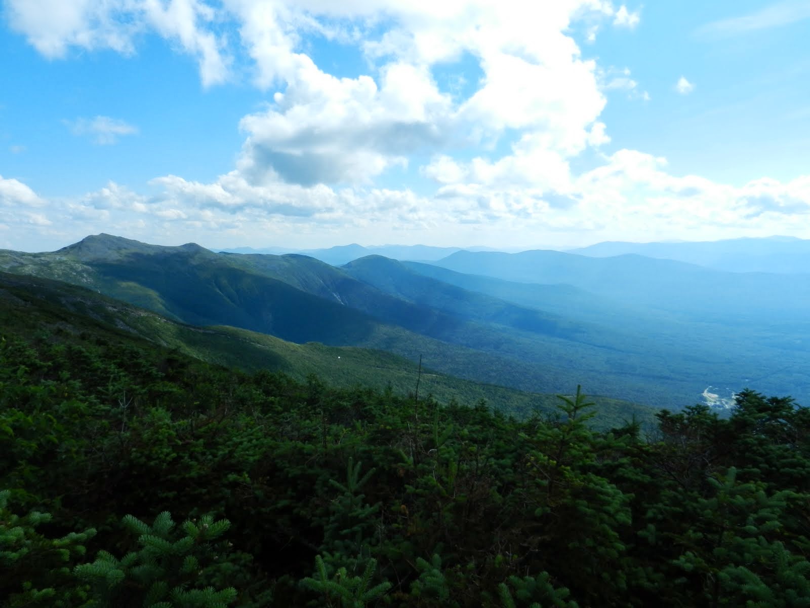
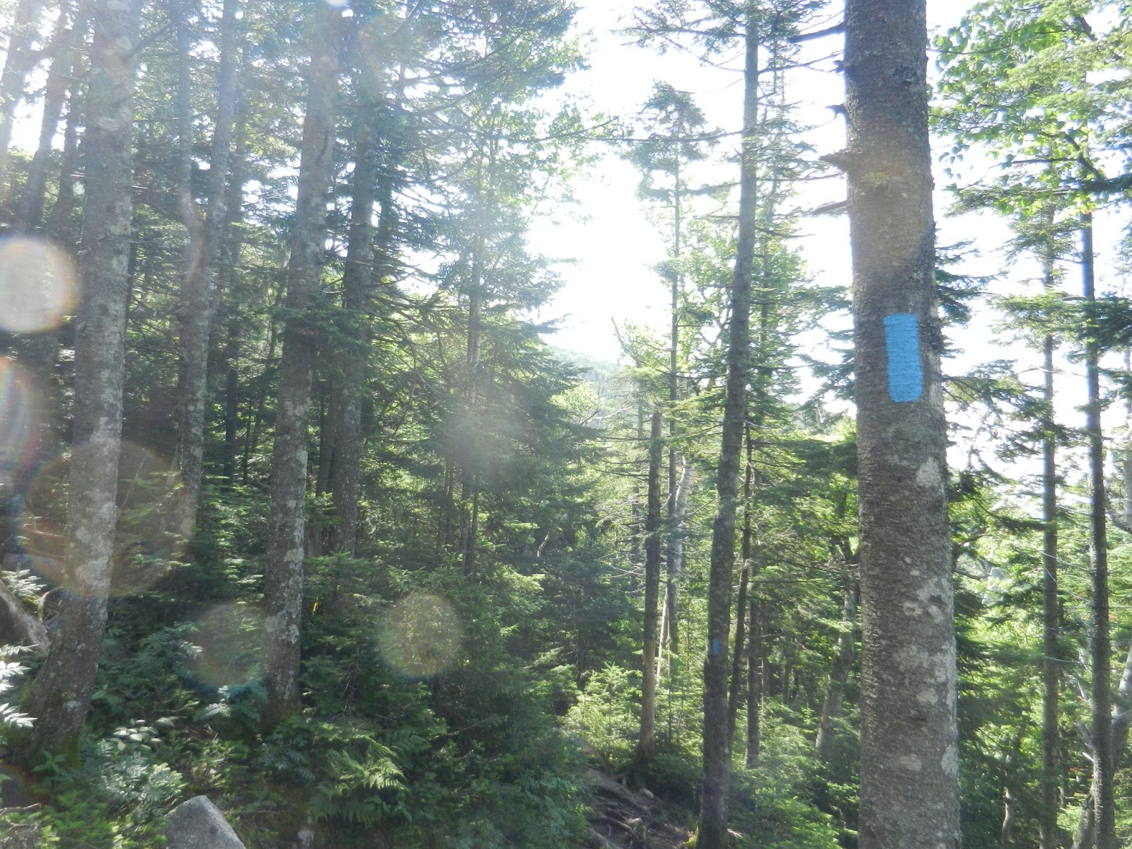
Once we got to alpine, all bets were off.  It got rocky, very rocky.  And bouldery, very bouldery.  I really question what people think when they say that a trail is easy.  They say Jewell is easy.  Let me tell you, it is not.  You need to maneuver rocks and small boulders, some which are tippy.   It was not fun.  Whatever glacier or volcano dropped this stuff was not in a good mood.  It seemed like it took forever for me to just to get to the Gulfside Trail.  And guess what?  More rocks.  More damn rocks. This trail was better than the Jewell though.  And the signs, oh the signs, sign signs everywhere signs.  So many trails in 1.4 miles.


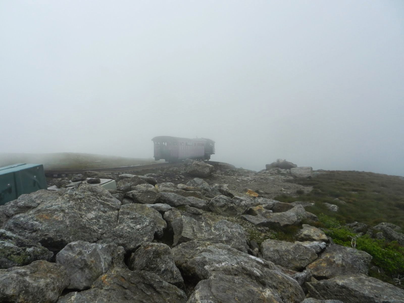
They say of you lose the trail, which we did, to follow the Cog railroad, which we did.  We saw a few trains go by.  There was waving, thumb upping.  I kinda felt like a celebrity.  Saw a few thru hikers go by when we realized, oops, the Gulfside is over there.  We carefully wondered over and took some cool pictures and continued on our way.  We waited for a train to pass so we could cross the tracks.


The hike continued and reached the Trinity Connector.  .2 miles to the summit.  .2 miles of tippy slabs of rock.  I swear that was the longest .2 miles of my life.  My friends continued on and I kept saying “I’m not dead yet.”  It was more mentally exhausting than physically exhausting.  I felt like it was harder to catch my breath.  They has been up to Washington before, but this was my first time. I plugged away.  Once I made it past the rock/boulder fields on Jewell, I knew I was going to make it.  I pushed, and pushed, and huffed, and puffed, and got myself to the summit.  YAY.


So #12 is in the books.  I stood in line, corrupted some young kids to do a shirtless pic, and took my picture with the sign.  We didn’t take a group shot because the line was LONG.  We did get a great picture by the Crawford Path sign.  Then I saw Jay who I hiked down Moosilauke with.  He was there for 2 4s (8, 12), and my two highest.  Will I see him again on 16?  Who knows.  We went inside, I had a pepperoni pizza and a very beany chili.  It tasted good then, but it kinda repeated on my on the way down.  We took a tour of the weather station, saw the living quarters, and attempted to find Marty.  Alas, it was time to go.  The clouds lifted nicely and revealed some awesome gorgeous scenery.  It would have been a nice trip in the fog, but this was nice to see the view.  And the clouds made it kind of awesome.  I resisted the urge to take the Cog down.  Long trip...oh well.


Remember the tippy rocks I told you about.  Well, I had to deal with them again.  It is not fun going up, but even less fun going down.  It is funny how you forget what you went through.  It is like the brain is saying “it’s not so bad, we will be back in no time.”  Like the people who said Jewel was easy, the brain lies.   And let me say, those happy little trees were laughing at me.  And one ate my new glove.  I plugged my way down the Jewell, murmuring some unmentionables.  My friends asked if wanted to be up front, I said no, but when we got to dirt path again, I would be flying...and I did.  I was looking for that bizarre sign that said N.T. trail, what the heck is that?  But it also says Cog RR .3 miles.   Which means the adventure is almost over.  


I hiked Washington.  It took a while, but I did it.  Actually only 4hr, or less, down.  Donna offered to drive us to the other trailhead.  The bathrooms were still open...YAY.  Got back to the car, went to Elvio’s, got great coffee at the Mobil station, and headed back.  I dropped off Roxanne at the Park and Ride and proceeded home.  I hurt a bit, but 2 beers and 3 Aleve did the job.  I even did Wachusett the next day, no pain.  However, I have spent the last two days under the influence of Benadryl.  I got some bites on Washington, but I was eaten alive on Wachusett.  I had a sore throat and was itchy for two days.  Screw that natural bug repelling stuff.  


More pictures

Saturday, July 13, 2013

CANNONBALL...or not

The good thing about being a teacher (only really) is that we have the summers off.  I can sleep in to whatever.   Well, since I have decided to pursue my 48, sleeping in has meant waking up when the sun isn't.  It was different Tuesday.  I was tired.  And my stomach still hurts.  It hurt all the way to Campton.  So after being up for about 4 hours, I decided to suck it up and bag Cannon.  It was only 2 miles right?  It can't be too hard, right?  I mean I attempted it before and aside from the granite BBs, it can't be too bad, right?    Yeah, right.  It was an exercise in perseverance, stamina, and figuring out how to use that compass.


My plan was simple.  2 up, 2 down, 5 hrs max.   Let me just say, I wanted to start at 2, but I am sure I was not on the trail until 2:30.  I huffed and puffed a bit but it got better.  I made it to the point where I turned around last time and thought that everything was fine after that.  I was so very wrong.  I thought I was almost there.  I was so very wrong.  The sun was shining, I thought I would see some great views.  Yup, wrong.  It would end up being my most defining moment.  At least for now.

Anyway, I got up to the lookout point, thought I was close to the summit.  FOG.  Then wind.  I thought I was I was lost.  I broke out the compass, compared it to the map.  Yup, not there yet.  Then came the mud.  The sucking mud.  Then some fog moved and I saw that I was no where near the summit.  I thought for a minute and would not give up.  More rocks, lots of places where I could twist an ankle, but I kept on going.  The I saw a cairn, and I thought it was over.  Climbed up a bit more and saw a few viewpoints, then the roped off area, completely shrouded in fog.  Yeah, I crossed the ropes, but you know, whatever.  Couldn't find the tower.  So I had some food, looked at the time and realized, I needed off the mountain and NOW.  I was tired.  I had no idea what would come out of the clouds.  I knew it would take some time.  I slipped and had to remind myself to slow down and get off the trail safely.  It was hard.  I was scared a bit.  I was alone, so I could talk to myself and curse all I wanted.  And you better believe that I did.  I even slid down the wet slabs.  I just wanted off the mountain.  Slow, steady, and carefully, I made it down the mountain.  In my mind it was over.  I danced off the trail.  I danced in the parking lot.  It was ugly, but I did it.


WELL, let's not dance so fast.  Yeah, I saw a cairn, but that is not the true summit.  The area around the tower is.  FAIL.  So I have to do it again.  Very sad.  I have two chances this summer so no big deal, but DAMN, that was not a fun hike.  Not at all.  I was scared, I thought I was lost.  I couldn't see.  I was all alone.  I had to go way outside my comfort level.  I had to trust myself.  I had to go down a trail I had no intention of ever hiking again.   I almost lost my camera, phone, and sanity.  Dropped my MP3 player in a puddle, but it survived as did my seat of my pants which I slid on.  I felt like I was being a baby.  Then I told my story on the 4K Facebook page and found out that trail was no walk in the park.  I heard all sorts of tales of woe and pain.  I felt a bit better to have made it out with a few bumps, bruises, and scrapes.  I will keep it as #11, but I still have to do it again for it to count.   Oh well.